
Geological Formations
Hover over the images to enlarge.
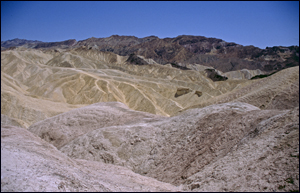
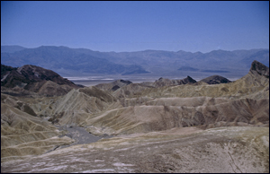
Artist Drive and Palette
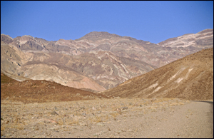
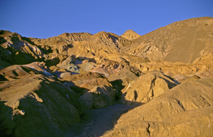
These formations are in Death Valley, California, USA. Artist's Drive rises up to the top of an alluvial fan fed by a deep canyon cut into the Black Mountains. Artist's Palette is on the face of the Black Mountains and is noted for having various colours of rock. These colours are caused by the oxidation of different metals (red, pink and yellow is from iron salts, green is from decomposing tuff-derived mica, and manganese produces the purple). Called the Artist Drive Formation, the rock unit provides evidence for one of the Death Valley area's most violently explosive volcanic periods. The Miocene-aged formation is made up of cemented gravel, playa deposits, and much volcanic debris, perhaps 5,000 feet (1500 m) thick. Chemical weathering and hydrothermal alteration are also responsible for the variety of colours displayed in the Artist Drive Formation and nearby exposures of the Furnace Creek Formation.
Badlands
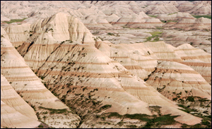
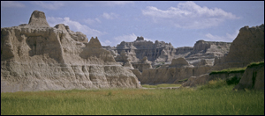
Badlands National Park, in southwest South Dakota preserves 242,756 acres (98,240 ha) of sharply eroded buttes, pinnacles, and spires blended with the largest protected mixed grass prairie in the United States. On-going rains, freezes and thaws have revealed millions of years of sediment that paint a colourful landscape on the prairies of south-western South Dakota. It contains the world's richest Oligocene epoch fossil beds, dating 23 to 35 million years old.
Bryce Canyon
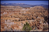
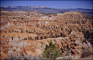
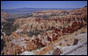
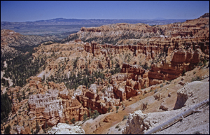
It is in Utah, USA and is famous for its worldly unique geology consists of a series of horseshoe-shaped amphitheaters carved from the eastern edge of the Paunsaugunt Plateau. The erosional force of frost-wedging and the dissolving power of rainwater have shaped the colourful limestone rock of the Claron Formation into bizarre shapes, including slot canyons, windows, fins, and spires called "hoodoos". Bryce Canyon was not formed from erosion initiated from a central stream, meaning it technically is not a canyon. Instead headward erosion has excavated large amphitheatre-shaped features in the Cenozoic-aged rocks of the Paunsagunt Plateau.
Grand Canyon
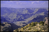
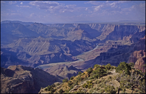
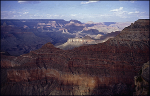
It is in Ariziona, USA. It is a steep-sided canyon carved by the Colorado River in the United States in the state of Arizona. The Grand Canyon is 277 miles (446 km) long, up to 18 miles (29 km) wide and attains a depth of over a mile (6,000 feet / 1,800 metres). Nearly two billion years of the Earth's geological history has been exposed as the Colorado River and its tributaries cut their channels through layer after layer of rock while the Colorado Plateau was uplifted. The Grand Canyon is part of the Colorado River basin which has developed over the past 40 million years. A recent study places the origins of the canyon beginning about 17 million years ago.
Moeraki Boulders
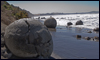
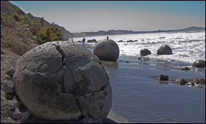
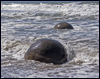
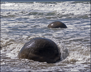
The Boulders are unusually large and spherical boulders lying along a stretch of Koekohe Beach on the wave cut Otago coast of New Zealand between Moeraki and Hampden. They occur scattered either as isolated or clusters of boulders within a stretch of beach where they have been protected in a scientific reserve. The erosion by wave action of mudstone, comprising local bedrock and landslides, frequently exposes embedded isolated boulders. These boulders are grey-colour septarian concretions, which have been exhumed from the mudstone enclosing them and concentrated on the beach by coastal erosion. Local Māori legends explained the boulders as the remains of eel baskets, calabashes, and kumara washed ashore from the wreck of Arai-te-uru, a large sailing canoe. The most striking aspect of the boulders is their unusually large size and spherical shape, with a distinct bimodal size distribution. Approximately one-third of the boulders range in size from about 0.5 to 1.0 metres (1.6 to 3.3 ft..) in diameter, the other two-thirds from 1.5 to 2.2 metres (5 to 7.3 ft..), mostly spherical or almost spherical. A small proportion of them are not spherical; being slightly elongated parallel to the bedding of the mudstone that once enclosed them.
Mount Etna
It is an active stratovolcano on the east coast of Sicily, Italy, close to Messina and Catania. It is the tallest active volcano in Europe, currently standing 3,329 m (10,922 ft.) high, though this varies with summit eruptions. It is the highest mountain in Italy south of the Alps. Etna covers an area of 1,190 km2 (459 sq. mi) with a basal circumference of 140 km. This makes it by far the largest of the three active volcanoes in Italy, being about two and a half times the height of the next largest, Mount Vesuvius. Mount Etna is one of the most active volcanoes in the world and is in an almost constant state of activity. The fertile volcanic soils support extensive agriculture, with vineyards and orchards spread across the lower slopes of the mountain and the broad Plain of Catania to the south. Due to its history of recent activity and nearby population, Mount Etna has been designated a Decade Volcano by the United Nations.
Mount Kilimanjaro
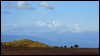
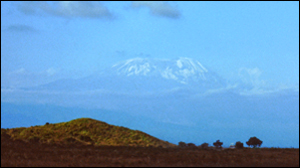
With its three volcanic cones, Kibo, Mawenzi, and Shira, is a dormant volcanic mountain in Kilimanjaro National Park, Kilimanjaro Region, Tanzania. It is the highest mountain in Tanzania, the highest mountain in Africa and the highest free-standing mountain in the world at 5,895 metres or 19,341 feet above sea level. Kilimanjaro is composed of three distinct volcanic cones: Kibo 5,895 m (19,341 ft.); Mawenzi 5,149 m (16,893 ft.); and Shira 3,962 m (13,000 ft.). Uhuru Peak is the highest summit on Kibo's crater rim. Kilimanjaro is a large stratovolcano. Two of its three peaks, Mawenzi and Shira, are extinct while Kibo (the highest peak) is dormant and could erupt again. The last major eruption has been dated to between 150,000 and 200,000 years ago. Although it is dormant, Kibo has fumaroles that emit gas in the crater. Several collapses and landslides have occurred on Kibo in the past, one creating the area known as the Western Breach.
Mount Tarawera
It is the volcano responsible for New Zealand's largest historic eruption. Located 24 kilometres southeast of Rotorua in the North Island, it consists of a series of rhyolitic lava domes that were fissured down the middle by an explosive basaltic eruption in 1886, which killed over a hundred people. These fissures run for about 17 kilometres northeast-southwest. The volcano's component domes include Ruawahia Dome (the highest at 1111 metres),Tarawera Dome and Wahanga Dome. It is surrounded by several lakes, most of which were created or drastically altered in the 1886 eruption.
Ngorongoro Crater
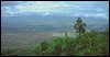
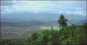
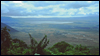
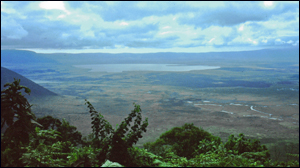
It is located 180 km (110 mi) west of Arusha in the Crater Highlands area of Tanzania. The main feature of the NCA is the Ngorongoro Crater, a large, unbroken, unflooded volcanic caldera. The crater, which formed when a giant volcano exploded and collapsed on itself some two to three million years ago, is 610 m (2,000 ft) deep and its floor covers 260 km2 (100 sq. mi). Estimates of the height of the original volcano range from fifteen to nineteen thousand feet (4500 to 5800 metres) high.
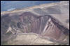
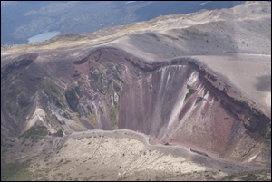
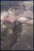
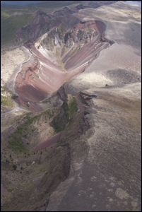
Ubehebe Crater
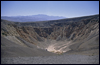
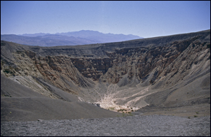
It is a large volcanic crater of the Ubehebe Craters volcanic field in the northern half of Death Valley, in Death Valley National Park, California, USA. Ubehebe Crater is located at the north tip of the Cottonwood Mountains. The crater is half a mile (one kilometre) wide and 500 to 777 feet (150 to 237 m) deep. The age of the crater is estimated from 2,000 to 7,000 years old. "Ubehebe" (pronounced YOU-bee-HEE-bee)is a Timbisha Native American word meaning "Big basket in the rock.". The crater was formed when magma migrated close to the surface and the heat of the magma flashed groundwater into steam, throwing large quantities of pulverized old rock and new magma across the stony alluvial fan draped across the valley floor. The magma rose through a fault that lies along the western base of Tin Mountain. Movement on this fault was responsible for uplift of the entire Cottonwood Mountains range.
Yellowstone National Park
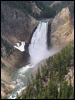
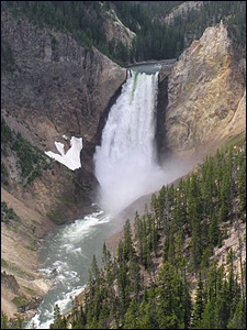
It is a national park located primarily in the U.S. state of Wyoming, although it also extends into Montana and Idaho. Yellowstone is at the northeastern end of the Snake River Plain, a great U-shaped arc through the mountains that extends from Boise, Idaho some 400 miles (640 km) to the west. This feature traces the route of the North American Plate over the last 17 million years as it was transported by plate tectonics across a stationary mantle hotspot. The landscape of present-day Yellowstone National Park is the most recent manifestation of this hotspot below the crust of the Earth. The Yellowstone Caldera is the largest volcanic system in North America. It has been termed a "supervolcano" because the caldera was formed by exceptionally large explosive eruptions. The current caldera was created by a cataclysmic eruption that occurred 640,000 years ago, which released 240 cubic miles (1,000 km³) of ash, rock and pyroclastic materials.
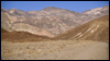
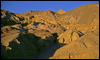
Zabriskie Point
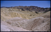
It is a part of Amargosa Range located in east of Death Valley in Death Valley National Park in the United States noted for its erosional landscape. It is composed of sediments from Furnace Creek Lake, which dried up 5 million years ago—long before Death Valley came into existence. They are developed on a mudstone foundation. Fine-grained sediments (silt and clay) were deposited in one of Death Valley's prehistoric lakes, then were buried by still more sediment, and finally compressed and weakly cemented to form the soft rock called mudstone.
Top of Page